

OPTIONS:
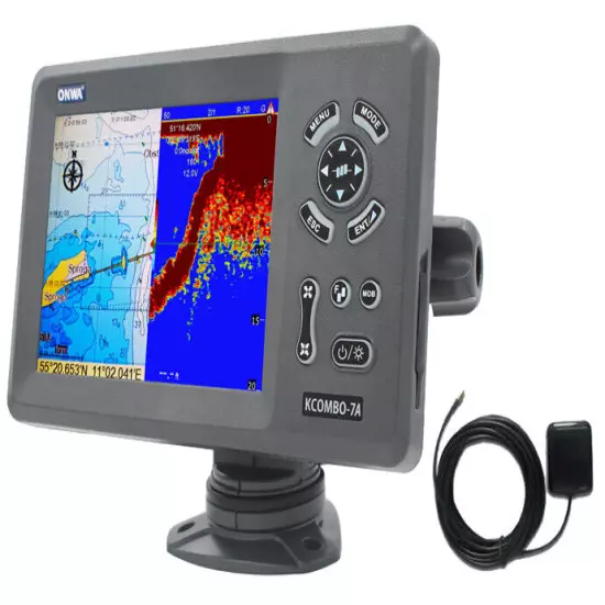
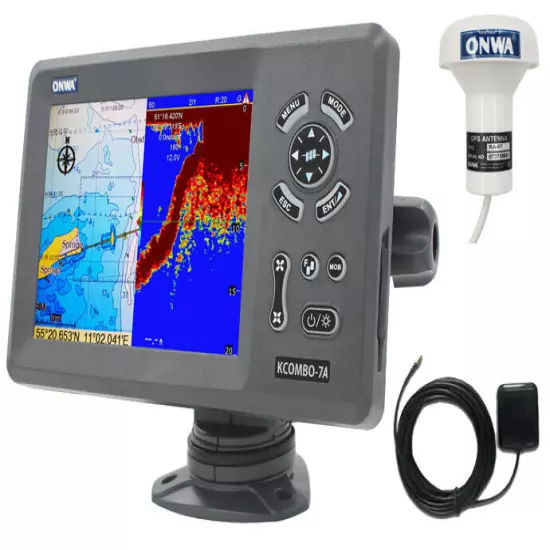
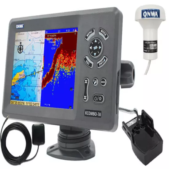
KCombo-7A without Transducer Inclusions: - Main Unit KCOMBO-7A - Standard
accessories - Quick Manuals - External GPS Antenna w/ 4m cable - Built-in Class
B+ AIS Transponder
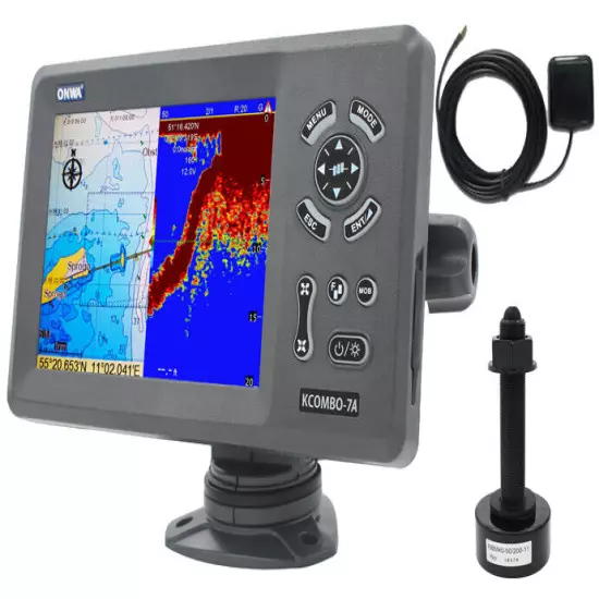
Kcombo-7A with Transom Mount Transducer Inclusions: - Main Unit KCOMBO-7A -
Standard accessories - Quick Manuals - External GPS Antenna w/ 4m cable -
Built-in Class B+ AIS Transponder - 600W Transom Mount Plastic Transducer with
built-in Temperature Sensor
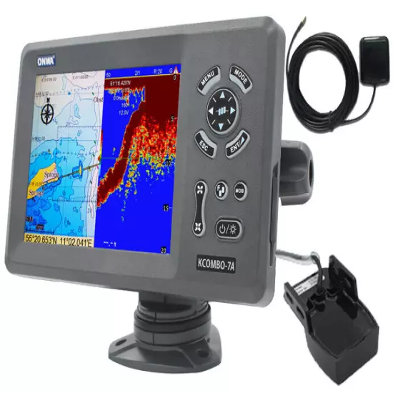
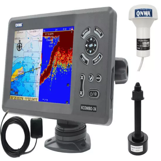
KCombo-7A with Plastic Transducer Inclusions: - Main Unit KCOMBO-7A -
Standard accessories - Quick Manuals - External GPS Antenna w/ 4m cable -
Built-in Class B+ AIS Transponder - 600W Thru-Hull Plastic Transducer with
built-in Temperature Sensor
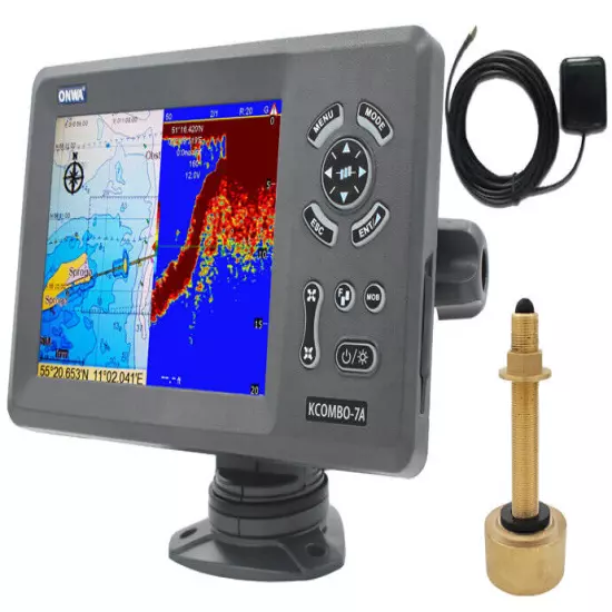
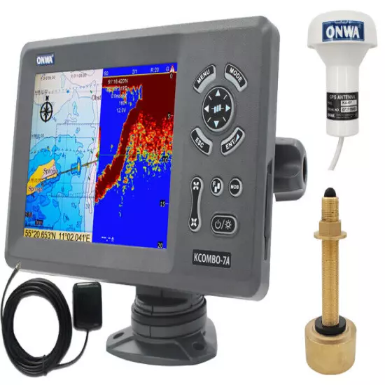
Kcombo-7A with Bronze Transducer Inclusions: - Main Unit KCOMBO-7A - Standard
accessories - Quick Manuals - External GPS Antenna w/ 4m cable - Built-in Class
B+ AIS Transponder - 600W Thru-Hull Bronze Transducer with built-in Temperature
Sensor
KCombo-7A w/ KA-07 GPS Antenna but without Transducer Inclusions: - Main Unit
KCOMBO-7A - Standard accessories - Quick Manuals - External GPS Antenna w/ 4m
cable - Built-in Class B+ AIS Transponder - KA-07 GPS Antenna (10m)
Kcombo-7A w/ KA-07 GPS Antenna w/ Transom Mount Transducer Inclusions: - Main
Unit KCOMBO-7A - Standard accessories - Quick Manuals - External GPS Antenna w/
4m cable - Built-in Class B+ AIS Transponder - KA-07 GPS Antenna (10m) - 600W
Transom Mount Plastic Transducerwith built-in Temperature Sensor
KCombo-7A w/ KA-07 GPS Antenna w/ Plastic Transducer Inclusions: - Main Unit
KCOMBO-7A - Standard accessories - Quick Manuals - External GPS Antenna w/ 4m
cable - Built-in Class B+ AIS Transponder - KA-07 GPS Antenna (10m) - 600W
Thru-Hull Plastic Transducer with built-in Temperature Sensor
Kcombo-7A w/ KA-07 GPS Antenna w/ Bronze Transducer Inclusions: - Main Unit
KCOMBO-7A - Standard accessories - Quick Manuals - External GPS Antenna w/ 4m
cable - Built-in Class B+ AIS Transponder - KA-07 GPS Antenna (10m) - 600W
Thru-Hull Bronze Transducer with built-in Temperature Sensor
FEATURES:
7 inches High resolution LCD,800×600 pixels
Built-in Class B+ AIS Transponder
Easy to use menu operation
sunlight viewable
C-Map NT Max Compatible
Digital Fishfinder Technology
Speed, Depth, water temperature and position
Ingress Protected to IP67
NOTE:
VHF Antenna Needed for the AIS transmission (not included, optional accessory
KA-159)
Compatible Maps
Built-in Fish Finder Feature
AIS Features
Specifications
Plotter Characteristics
Waypoints/icons 12,000 user waypoints with name, symbol,
3 system waypoints: MOB,Start,cursor
10 proximity waypoints Routes 30 routes waypoint up to 170 points each,
plus MOB and Track Navigation or Goto Track modes Tracks 8,000 points
automatic track log;
10 saved tracks (up to 8000 track points each)
lets you retrace your path in both directions Alarms XTE, Anchor drag,
arrival, speed, voltage, proximity waypoint,
Timer and AIS (CPA and TCPA) alarm Drawing 1000 Drawing Marks; 2000 Drawing
Lines (40 points each);
1000 Drawing Place Name; 8 colors for Drawing Pallete Normal
Daylight exposed to sunlight
Night in dark environment
NOAA paperchart colors Tides Built-in Worldwide Tide Data Position Format
Lat/Lon Basemap Worldwide External Map Compatible with K-Chart 2.0, K-Chart
3.0, C-Map Max and Navionics+ User Data Storage Internal backup of user
settings or external SD-card Plot Interval 5secs to 60 mins or 0.01 to 10nm
Plotting Scales 0.001 to 700nm AIS 700 targets display AIS Target Tracking
1000 Automatically saved tracks (100 points each)
10 Manually saved tracks (300 points each) Perspective view On/off (available
for C-Map only) Celestial Sunrise/Sunset Moonrise/Moonset
GPS Receiver Characteristics
Receiver 50 parallel channel GNSS receiver continuously tracks and
uses up to 50 satellites to compute and update your position Acquisition time
Cold start: 29 seconds
Hot start: 1 second Update rate 1 second Accuracy Position:3 meters(95%)
without S/A
Velocity: 0.1 meter/sec without S/A SBAS Supported Satellite System GPS and
Beidou Dynamics Altitude: 18,000 m
Velocity: 515 m/s Datum WGS 84 & user defined Antenna GPS Patch Antenna
GPS Interface
GSP Data RS232 input/output, NMEA 0183 V3.01 and V4.11 GPS Input Baudrate
Auto Scan (4800, 9600, 19200 and 38400) GPS Output Baudrate Selectable among
4800, 9600, 19200 and 38400
AIS Interface
AIS Data RS232 output VDO, VDM, GGA, GSA, GSV and VTG AIS Output Baudrate
38,400
AIS Characteristics
Frequency Rate 156.025 MHz~162.025 MHz Access Scheme SOTDMA Channel Bandwidth
25 KHz Modulation GMSK Data Rate 9,600 bps Number of AIS Transmitter 1
Number of AIS Receiver 2 AIS Channel 1 CH 87B (161.975 MHz) AIS Channel 2 CH
88B (162.025 MHz) Tx Power Output >5 Watt (37 dBm ± 1.5 dB) RX Sensitivity
123dBm @ 20% PER RX Message Format AIS Class A and B messages Comply Standard
IEC-62287 IEC 62287-2 Ed. 2.0:2017
Echo Sounder Characteristics
Echo Color 16 colors (including background color) according to echo
intensity. The background color is selectable from blue, light blue, white and
black Basic Range Meters 5/10/20/40/80/150/200/300/600/1000
Feet 15/30/60/120/200/400/600/1000/2000/3000
Fathoms 3/5/10/20/40/80/150/300/600
The basic ranges can be changed on the system menu. Range Shift Up to 1000
meters (3000 feet,600 fathoms) Zoom Range Times 2,3,4 and 6 ranges Bottom Lock
Expansion Range 5/10 meters,10/20 feet,2/5 fathoms Auto Mode Automatic
adjustment of range and gain Display Mode High Frequency (200K),Low Frequency
50K), Dual (200K and 50K 1/2 display on each),
Zoom (200K and 50K zoom) and A-scope Display Zoom Display Marker Zoom, Bottom
Zoom and Bottom-lock Expansion Display Advance Speed Lines/TX:Freeze, 1/8,
1/4, 1/2, 1/1, 2/1, 4/1, 6/1,8/1 and 10/1 TX Frequency 50 and 200kHz
alternately transmitted) Power Output 600W Pulse-length/TX rate
Display End Depth (m) 5 10 20 40 80 150 200 300 600 1000
Pulse-Length 200K(µs) 120 220 320 520 920 1020 1020 1020 1020 1020
Pulse-Length 50K(µs) 170 270 370 570 970 1070 1070 1070 1070 1070
TX Rate(pulse/min) 2000 1333 706 353 171 98 75 53 38 27
TX period(millisecond) 30 45 85 170 350 610 800 1120 1580 2200
Interference Rejecter Rejects unwanted signals by comparing last and present
echoes in strength. Alarm Fish and Bottom alarms,
Temperature alarm (sensor required)
NMEA Sentence Supported
INPUT (Auto scan Baudrate)
GGA, GLL, GSA, GSV, RMC, HDG, HDM, HDT
VTG, ZDA, MTW, VWR, VWT, MWD, VPW, VHW
TLL, TTM, VDO, VDM, GNS, MTA
RMA, DBT, DPT, MWV, BWC, XTE, ZDL, WPL, AAM,
APB, BOD, RMB, DSC, MDA, RPM, XDR OUTPUT Baudrate: Selectable 4800, 9600,
19200, 38400
GGA, GLL, RMC, GSA, GSV, AAM, APA
APB, BOD, BWC, BWR, DBT, DPT, HDT
MTW, RMB, TLL, VTG, WPL, XTE, ZDA
ZTG, ZDL, MWD, VPW, VWR, VWT OUTPUT for Autopilot APA, APB, BOD, XTE
Power Supply
10.5 to 30VDC, current drain 2.0A at 12V
PHYSICAL
Size 155.2mm(H)X243mm(W)X84.6mm(D) Weight 0.83 kg Display 7-inch Color TFT
dayview LCD, 800×600 pixels Waterproofing Display unit: IP66
Antenna unit: IP66 Temperature range Display unit: -15℃ to +55℃
Antenna unit: -25℃ to +70℃
FREQUENTLY ASKED QUESTIONS (FAQ'S)
1. How to get NMEA0183 output from Onwa Chartplotters ? 2. How to connect
external data to Onwa chartplotter ?
For KP-708 and KCombo-7 connect external data to orange wire + and yellow
wire – of power/data cable
All Onwa chartplotters can auto detect the baudrate of external data input
All Onwa chartplotters can support NMEA0183 ver.3.0
KCombo-7A without Transducer Inclusions: - Main Unit KCOMBO-7A - Standard
accessories - Quick Manuals - External GPS Antenna w/ 4m cable - Built-in Class
B+ AIS Transponder
Kcombo-7A with Transom Mount Transducer Inclusions: - Main Unit KCOMBO-7A -
Standard accessories - Quick Manuals - External GPS Antenna w/ 4m cable -
Built-in Class B+ AIS Transponder - 600W Transom Mount Plastic Transducer with
built-in Temperature Sensor
KCombo-7A with Plastic Transducer Inclusions: - Main Unit KCOMBO-7A -
Standard accessories - Quick Manuals - External GPS Antenna w/ 4m cable -
Built-in Class B+ AIS Transponder - 600W Thru-Hull Plastic Transducer with
built-in Temperature Sensor
Kcombo-7A with Bronze Transducer Inclusions: - Main Unit KCOMBO-7A - Standard
accessories - Quick Manuals - External GPS Antenna w/ 4m cable - Built-in Class
B+ AIS Transponder - 600W Thru-Hull Bronze Transducer with built-in Temperature
Sensor
KCombo-7A w/ KA-07 GPS Antenna but without Transducer Inclusions: - Main Unit
KCOMBO-7A - Standard accessories - Quick Manuals - External GPS Antenna w/ 4m
cable - Built-in Class B+ AIS Transponder - KA-07 GPS Antenna (10m)
Kcombo-7A w/ KA-07 GPS Antenna w/ Transom Mount Transducer Inclusions: - Main
Unit KCOMBO-7A - Standard accessories - Quick Manuals - External GPS Antenna w/
4m cable - Built-in Class B+ AIS Transponder - KA-07 GPS Antenna (10m) - 600W
Transom Mount Plastic Transducerwith built-in Temperature Sensor
KCombo-7A w/ KA-07 GPS Antenna w/ Plastic Transducer Inclusions: - Main Unit
KCOMBO-7A - Standard accessories - Quick Manuals - External GPS Antenna w/ 4m
cable - Built-in Class B+ AIS Transponder - KA-07 GPS Antenna (10m) - 600W
Thru-Hull Plastic Transducer with built-in Temperature Sensor
Kcombo-7A w/ KA-07 GPS Antenna w/ Bronze Transducer Inclusions: - Main Unit
KCOMBO-7A - Standard accessories - Quick Manuals - External GPS Antenna w/ 4m
cable - Built-in Class B+ AIS Transponder - KA-07 GPS Antenna (10m) - 600W
Thru-Hull Bronze Transducer with built-in Temperature Sensor
FEATURES:
7 inches High resolution LCD,800×600 pixels
Built-in Class B+ AIS Transponder
Easy to use menu operation
sunlight viewable
C-Map NT Max Compatible
Digital Fishfinder Technology
Speed, Depth, water temperature and position
Ingress Protected to IP67
NOTE:
VHF Antenna Needed for the AIS transmission (not included, optional accessory
KA-159)
Compatible Maps
Built-in Fish Finder Feature
AIS Features
Specifications
Plotter Characteristics
Waypoints/icons 12,000 user waypoints with name, symbol,
3 system waypoints: MOB,Start,cursor
10 proximity waypoints Routes 30 routes waypoint up to 170 points each,
plus MOB and Track Navigation or Goto Track modes Tracks 8,000 points
automatic track log;
10 saved tracks (up to 8000 track points each)
lets you retrace your path in both directions Alarms XTE, Anchor drag,
arrival, speed, voltage, proximity waypoint,
Timer and AIS (CPA and TCPA) alarm Drawing 1000 Drawing Marks; 2000 Drawing
Lines (40 points each);
1000 Drawing Place Name; 8 colors for Drawing Pallete Normal
Daylight exposed to sunlight
Night in dark environment
NOAA paperchart colors Tides Built-in Worldwide Tide Data Position Format
Lat/Lon Basemap Worldwide External Map Compatible with K-Chart 2.0, K-Chart
3.0, C-Map Max and Navionics+ User Data Storage Internal backup of user
settings or external SD-card Plot Interval 5secs to 60 mins or 0.01 to 10nm
Plotting Scales 0.001 to 700nm AIS 700 targets display AIS Target Tracking
1000 Automatically saved tracks (100 points each)
10 Manually saved tracks (300 points each) Perspective view On/off (available
for C-Map only) Celestial Sunrise/Sunset Moonrise/Moonset
GPS Receiver Characteristics
Receiver 50 parallel channel GNSS receiver continuously tracks and
uses up to 50 satellites to compute and update your position Acquisition time
Cold start: 29 seconds
Hot start: 1 second Update rate 1 second Accuracy Position:3 meters(95%)
without S/A
Velocity: 0.1 meter/sec without S/A SBAS Supported Satellite System GPS and
Beidou Dynamics Altitude: 18,000 m
Velocity: 515 m/s Datum WGS 84 & user defined Antenna GPS Patch Antenna
GPS Interface
GSP Data RS232 input/output, NMEA 0183 V3.01 and V4.11 GPS Input Baudrate
Auto Scan (4800, 9600, 19200 and 38400) GPS Output Baudrate Selectable among
4800, 9600, 19200 and 38400
AIS Interface
AIS Data RS232 output VDO, VDM, GGA, GSA, GSV and VTG AIS Output Baudrate
38,400
AIS Characteristics
Frequency Rate 156.025 MHz~162.025 MHz Access Scheme SOTDMA Channel Bandwidth
25 KHz Modulation GMSK Data Rate 9,600 bps Number of AIS Transmitter 1
Number of AIS Receiver 2 AIS Channel 1 CH 87B (161.975 MHz) AIS Channel 2 CH
88B (162.025 MHz) Tx Power Output >5 Watt (37 dBm ± 1.5 dB) RX Sensitivity
123dBm @ 20% PER RX Message Format AIS Class A and B messages Comply Standard
IEC-62287 IEC 62287-2 Ed. 2.0:2017
Echo Sounder Characteristics
Echo Color 16 colors (including background color) according to echo
intensity. The background color is selectable from blue, light blue, white and
black Basic Range Meters 5/10/20/40/80/150/200/300/600/1000
Feet 15/30/60/120/200/400/600/1000/2000/3000
Fathoms 3/5/10/20/40/80/150/300/600
The basic ranges can be changed on the system menu. Range Shift Up to 1000
meters (3000 feet,600 fathoms) Zoom Range Times 2,3,4 and 6 ranges Bottom Lock
Expansion Range 5/10 meters,10/20 feet,2/5 fathoms Auto Mode Automatic
adjustment of range and gain Display Mode High Frequency (200K),Low Frequency
50K), Dual (200K and 50K 1/2 display on each),
Zoom (200K and 50K zoom) and A-scope Display Zoom Display Marker Zoom, Bottom
Zoom and Bottom-lock Expansion Display Advance Speed Lines/TX:Freeze, 1/8,
1/4, 1/2, 1/1, 2/1, 4/1, 6/1,8/1 and 10/1 TX Frequency 50 and 200kHz
alternately transmitted) Power Output 600W Pulse-length/TX rate
Display End Depth (m) 5 10 20 40 80 150 200 300 600 1000
Pulse-Length 200K(µs) 120 220 320 520 920 1020 1020 1020 1020 1020
Pulse-Length 50K(µs) 170 270 370 570 970 1070 1070 1070 1070 1070
TX Rate(pulse/min) 2000 1333 706 353 171 98 75 53 38 27
TX period(millisecond) 30 45 85 170 350 610 800 1120 1580 2200
Interference Rejecter Rejects unwanted signals by comparing last and present
echoes in strength. Alarm Fish and Bottom alarms,
Temperature alarm (sensor required)
NMEA Sentence Supported
INPUT (Auto scan Baudrate)
GGA, GLL, GSA, GSV, RMC, HDG, HDM, HDT
VTG, ZDA, MTW, VWR, VWT, MWD, VPW, VHW
TLL, TTM, VDO, VDM, GNS, MTA
RMA, DBT, DPT, MWV, BWC, XTE, ZDL, WPL, AAM,
APB, BOD, RMB, DSC, MDA, RPM, XDR OUTPUT Baudrate: Selectable 4800, 9600,
19200, 38400
GGA, GLL, RMC, GSA, GSV, AAM, APA
APB, BOD, BWC, BWR, DBT, DPT, HDT
MTW, RMB, TLL, VTG, WPL, XTE, ZDA
ZTG, ZDL, MWD, VPW, VWR, VWT OUTPUT for Autopilot APA, APB, BOD, XTE
Power Supply
10.5 to 30VDC, current drain 2.0A at 12V
PHYSICAL
Size 155.2mm(H)X243mm(W)X84.6mm(D) Weight 0.83 kg Display 7-inch Color TFT
dayview LCD, 800×600 pixels Waterproofing Display unit: IP66
Antenna unit: IP66 Temperature range Display unit: -15℃ to +55℃
Antenna unit: -25℃ to +70℃
FREQUENTLY ASKED QUESTIONS (FAQ'S)
1. How to get NMEA0183 output from Onwa Chartplotters ? 2. How to connect
external data to Onwa chartplotter ?
For KP-708 and KCombo-7 connect external data to orange wire + and yellow
wire – of power/data cable
All Onwa chartplotters can auto detect the baudrate of external data input
All Onwa chartplotters can support NMEA0183 ver.3.0
| Brand | ONWA |
|---|---|
| Country/Region of Manufacture | China |
| Features | Built-in Class B+ AIS Transponder, Chart Plotting, Color Display, Depth Alarm, Depth Indicator, Fish Finder Feature, GPS |
| Function | GPS Chart Plotter with Fish Finder & Class B+ AIS |
| MPN | Does Not Apply |
| Power Source | DC |
| Screen Resolution | 800 x 600 |
